Where is South Dakota located in the US?
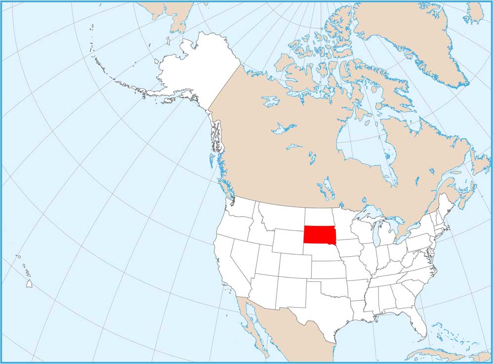
South Dakota is located in the north-central region of the United States, squarely within the Great Plains and Midwest. It is positioned south of North Dakota, north of Nebraska, east of Wyoming and Montana, and west of Minnesota and Iowa. This central placement makes it a key part of America's heartland, accessible for cross-country travel and home to iconic natural and historical sites. Its distinct borders help pinpoint its location easily.
What states directly border South Dakota?
South Dakota is bordered by six states. To the north, it shares a boundary with North Dakota. To the east, you will find Minnesota and Iowa. Nebraska lies directly to its south. On its western side, South Dakota shares borders with both Wyoming and Montana. These surrounding states form a clear geographical outline, making it simple to identify South Dakota on a map. Knowing these neighbors is essential for understanding its regional context.
Is South Dakota part of the Midwest or Western US?
South Dakota is primarily considered a core state of the Midwestern United States. While its westernmost parts, particularly the Black Hills, share some characteristics with the Western US, the state's dominant geography, culture, and agricultural identity align it firmly with the Midwest. This regional classification helps pinpoint its location on a map and provides context for its climate, economy, and the overall character of its landscape and communities.
How can I find Mount Rushmore by locating South Dakota first?
Once you locate South Dakota on the US map, zoom into its western region. Mount Rushmore National Memorial is situated within the Black Hills, a distinct mountainous area in southwestern South Dakota. Search for "Mount Rushmore" or "Black Hills" on any mapping application within South Dakota, and the landmark will appear. Knowing the state's position is the first step to navigating to this iconic national treasure and other attractions in the area.
What are the major cities in South Dakota and where are they located?
South Dakota's two largest cities are Sioux Falls, located in the southeastern corner of the state, and Rapid City, situated in the western part near the Black Hills. Other significant cities include Aberdeen in the northeast and Pierre, the state capital, which is centrally located along the Missouri River. Identifying these cities on a map helps to understand population distribution and plan visits to major hubs within the state.
where is south dakota, south dakota map, location of south dakota, what states border south dakota, south dakota on us map for travel, find south dakota united states, south dakota geographic location, map of south dakota attractions, how to get to south dakota, midwest states locationDiscover the exact placement of South Dakota on the United States map, understanding its central location and unique geographic features that make it a prominent state for both residents and visitors. This comprehensive guide helps you quickly pinpoint South Dakota, explore its bordering states, and visualize its position relative to major regions like the Midwest. Whether you are planning a cross-country road trip, researching historical landmarks like Mount Rushmore, or simply curious about US geography, knowing South Dakota's precise whereabouts is crucial. We delve into how its location influences travel routes, access to national parks, and overall regional appeal. Learn about typical travel times from key US cities, and explore what makes South Dakota a distinct destination. Our insights help you plan your next adventure, consider local attractions, or simply broaden your geographical knowledge. This resource will guide you on how to find directions, understand travel distances, and identify unique points of interest once you have its location firmly in mind. Prepare to explore this fascinating part of America.
- Where is South Dakota positioned geographically in the US? - South Dakota is located in the north-central United States, a core part of the Great Plains and Midwest region. It is centrally situated, flanked by six distinct bordering states, making it a prominent feature in the country's interior. This position provides a clear visual anchor on any US map.
- What are the surrounding states of South Dakota? - South Dakota is surrounded by North Dakota to the north, Minnesota and Iowa to the east, Nebraska to the south, and Wyoming and Montana to the west. These six states form a clear, identifiable perimeter around South Dakota, aiding in its quick location on a map.
- Is South Dakota in the Midwest region? - Yes, South Dakota is firmly categorized as a Midwestern state. While its western areas touch upon some characteristics of the American West, its dominant geography, agricultural focus, and cultural ties align it perfectly with the broader Midwest region. This helps pinpoint its location and character.
- How can I visually locate South Dakota on a map quickly? - To quickly find South Dakota, first locate North Dakota, its immediate northern neighbor. Then, look directly south. You can also find Nebraska to its south or pinpoint the cluster of states including Minnesota, Iowa, Wyoming, and Montana around its borders. Its central placement is distinctive.
- What major highways go through South Dakota? - Interstate 90 (I-90) is a primary east-west highway traversing South Dakota, connecting Sioux Falls in the east to Rapid City and the Black Hills in the west. Interstate 29 (I-29) runs north-south through the eastern part of the state, linking it to North Dakota and Nebraska. These routes are crucial for travel.
- Why is knowing South Dakota's location important for travelers? - Knowing South Dakota's location is vital for travel planning, helping estimate distances, plan routes, and identify nearby attractions. Its central US position makes it a key stop for cross-country journeys. Understanding its location helps travelers efficiently navigate to destinations like Mount Rushmore and explore the state's unique regional features effectively.
- What famous landmarks are near South Dakota's borders? - South Dakota is home to iconic landmarks such as Mount Rushmore and Badlands National Park, both situated in the western part of the state. These significant sites are well within its borders, making the state itself the primary location for these world-renowned attractions. The Missouri River also flows prominently through the state.
Understanding South Dakota's Placement in the US
Locating South Dakota on the United States map is a straightforward process, revealing a state nestled squarely in the north-central part of the country. Many refer to it as a key component of the American Midwest, characterized by its vast prairies, unique badlands, and the iconic Black Hills. Pinpointing its exact position helps travelers, students, and curious individuals gain a better understanding of US geography and planning potential journeys. Knowing where South Dakota lies informs decisions about travel routes, distances, and what other states one might encounter on the way to this distinctive destination. It serves as a gateway to exploring both the natural wonders and cultural richness found throughout the heartland.
Understanding South Dakota's geographical context is more than just identifying a spot on a map; it involves recognizing its strategic importance within the continental United States. Its central placement means it shares borders with several other states, forming a nexus for regional travel and economic activity. This position also influences its climate, landscapes, and the types of experiences available to visitors. From agricultural heartlands to rugged wilderness, South Dakota’s location encapsulates a diverse range of American terrains, making it a compelling point of interest for anyone exploring the country's interior. Planning a visit or simply learning about US states becomes much clearer when you have a solid grasp of its geographical coordinates.
For those new to US geography or planning their first trip to the region, visualizing South Dakota's position simplifies the entire process. Imagine drawing a vertical line down the middle of the continental US and a horizontal line across. South Dakota would fall comfortably near the intersection of these imaginary lines in the upper portion. This central location makes it accessible from various corners of the nation, inviting cross-country adventurers and those seeking a unique American experience. It is a destination that truly embodies the spirit of the American plains, offering a blend of history, natural beauty, and modern hospitality that starts with knowing exactly where to find it.
How to Locate South Dakota on a Map
Which US region is South Dakota a part of?
South Dakota is firmly situated within the Midwestern region of the United States. This designation helps to quickly narrow down its location on any map. The Midwest is a broad area, often recognized for its agricultural prowess, friendly communities, and distinct four seasons. South Dakota perfectly embodies many of these characteristics, lying within the upper tier of the region. When you consult a map, look for the block of states directly west of Minnesota and Iowa, and north of Nebraska. This regional understanding provides a crucial starting point for accurately finding the state without having to scan the entire continental US map indiscriminately. It truly is a quintessential part of America's heartland.
Identifying South Dakota as part of the Midwest is also helpful for understanding its cultural and economic ties. The states in this region often share similar historical backgrounds, industries, and even dialects, creating a cohesive identity. For instance, neighboring North Dakota, Nebraska, and Minnesota are also Midwest states, forming a natural cluster around South Dakota. This regional grouping facilitates a more intuitive navigation of the map, allowing you to anticipate its approximate location before you even zoom in. Keep in mind that regional definitions can sometimes vary slightly, but South Dakota consistently falls within the widely accepted boundaries of the Midwest, making its search much simpler.
Ultimately, knowing its regional classification serves as a powerful mnemonic device for map-reading and geographic comprehension. It helps solidify South Dakota's place in your mental map of the United States, connecting it to other familiar states and landmarks. When viewing a physical or digital map, mentally segment the US into its primary regions. Once you've identified the Midwest section, South Dakota will naturally stand out as one of its prominent northern components. This systematic approach ensures you can quickly and confidently locate South Dakota, whether you are planning a trip to see Mount Rushmore or simply expanding your general knowledge of American geography.
What states border South Dakota, and how do they help locate it?
Understanding South Dakota's neighboring states provides an excellent navigational framework for quickly locating it on any map. The state is bordered by six other states, creating a distinct geographical outline that is easy to identify. To the north lies North Dakota, forming a straightforward twin-state relationship. To its east, you'll find Minnesota and Iowa, which are distinct markers for the eastern boundary. Nebraska sits directly to the south, creating a clear southern border. Finally, to the west, South Dakota shares lines with Wyoming and Montana, anchoring its position within the vast Western Plains. These adjacent states form a natural locator grid.
When you look at a map, finding these bordering states first can act like a set of geographic signposts. For instance, once you spot North Dakota, you know to look immediately south for South Dakota. Similarly, if you locate Nebraska, South Dakota is directly north. This method is incredibly effective because these surrounding states are often more easily recognizable for some individuals, or they might serve as travel waypoints. By identifying the cluster of North Dakota, Minnesota, Iowa, Nebraska, Wyoming, and Montana, South Dakota's unique shape and position become unmistakably clear, almost like a puzzle piece fitting perfectly into its designated spot within the national landscape.
Furthermore, recognizing these borders helps in planning travel itineraries and understanding regional connections. If you are traveling from Denver, Colorado, for example, you would logically pass through Wyoming or Nebraska before entering South Dakota. This knowledge reinforces the practical utility of knowing its neighbors beyond mere identification. The clear geographical lines created by these borders simplify the task of pinpointing South Dakota, making it an efficient and reliable method for map-reading. Consider these bordering states as essential landmarks that define and highlight South Dakota's exact placement on the grand canvas of the United States map.
- North: North Dakota
- East: Minnesota, Iowa
- South: Nebraska
- West: Wyoming, Montana
What major landmarks help identify South Dakota on a map?
Several prominent landmarks within South Dakota are globally recognized, and knowing their locations can greatly assist in finding the state on a map. The most famous is undoubtedly Mount Rushmore National Memorial, carved into the granite of the Black Hills. When you spot the Black Hills region on a detailed map, often highlighted as a distinctive mountainous area in the generally flat western part of the state, you're looking right at South Dakota. This iconic monument acts as a powerful visual cue, drawing the eye directly to its home state. For many, Mount Rushmore is synonymous with South Dakota, making its location a primary identifier.
Beyond Mount Rushmore, the Badlands National Park also serves as an excellent geographical marker. This park features dramatically eroded buttes, pinnacles, and spires, and it is located in the southwestern part of South Dakota. On a map, the Badlands often appear as a unique geological formation or a designated national park area, providing another strong visual reference point. Its distinct appearance and protected status mean it is typically well-marked on various maps, making it a reliable feature for confirming you have indeed found South Dakota. These natural wonders are not just tourist attractions; they are key geographical anchors.
Additionally, the Missouri River, a major waterway, flows through the eastern and central parts of South Dakota. While a river might seem less specific than a mountain carving, its significant presence on maps, often forming a clear geographical divide or boundary within the state, helps to delineate its internal layout and overall position. Major cities like Sioux Falls and Rapid City, though smaller than national landmarks, are also often labeled on maps and can serve as urban identifiers once you've generally located the state. Together, these natural and man-made landmarks provide a comprehensive set of visual clues for confidently identifying South Dakota's place on the US map.
Common Questions About South Dakota's Location
Is South Dakota considered a Great Plains state?
Yes, South Dakota is absolutely considered a core state within the Great Plains region of the United States. This vast physiographic province covers much of the central North American continent, characterized by its expansive, flat to gently rolling grasslands. South Dakota's landscape is largely dominated by these plains, especially in its eastern and central parts, before transitioning to the rugged Black Hills in the west. This geographical classification is crucial for understanding its climate, agricultural practices, and the natural ecosystems found within its borders. Its Great Plains identity shapes everything from its weather patterns to its historical development and current economic activities. It truly is a defining characteristic of the state's natural environment.
The Great Plains designation for South Dakota is more than just a label; it describes the very essence of its geography and environmental features. Imagine endless skies and broad horizons, which are typical of this region. The fertile soils of the eastern plains support extensive agriculture, particularly corn and soybeans, reflecting the region's productive capacity. Further west, the drier shortgrass prairies are ideal for ranching. This consistent Great Plains identity helps to immediately place South Dakota in a specific environmental and agricultural context on any US map. It signals to map users that they are looking at a state with wide open spaces and a strong connection to the land, distinguishing it from mountainous or coastal states.
Therefore, when you see South Dakota on a map, knowing it belongs to the Great Plains helps you anticipate the kind of terrain and climate you might expect. This understanding is invaluable for anyone planning outdoor activities, agricultural research, or simply studying the diverse landscapes of the United States. It influences travel preparation, from packing appropriate clothing for variable weather to understanding the distances between towns. The Great Plains identity is a fundamental aspect of South Dakota's geography, providing a clear and immediate understanding of its environmental character and its place within the larger North American landscape. It provides an immediate sense of scale and natural habitat.
How far is South Dakota from major US cities?
The distance of South Dakota from major US cities varies significantly based on which specific city and which part of South Dakota you are considering. For instance, from Minneapolis, Minnesota, a major Midwestern hub, South Dakota's eastern border is relatively close, with Sioux Falls being approximately a 3.5-hour drive away. However, reaching Rapid City and the Black Hills in western South Dakota from Minneapolis would take closer to 9-10 hours, covering a much greater distance across the state. These variations highlight the importance of consulting a map or GPS for precise travel planning and understanding the state's expansive nature. Always consider your exact destination within South Dakota when calculating travel times and distances.
For travelers coming from more distant major metropolitan areas, the journey to South Dakota requires substantial planning. From Chicago, Illinois, a drive to Sioux Falls typically spans around 8-9 hours, while reaching Rapid City could extend to 14-15 hours. From Denver, Colorado, a popular starting point for Western adventures, Rapid City is roughly a 6-7 hour drive, demonstrating closer proximity to the state's western half. West Coast cities like Los Angeles or Seattle would entail multi-day road trips, often exceeding 20 hours of driving time. Understanding these broad distances helps set realistic expectations for travel duration and necessary accommodations along the way. Planning ahead is key.
These distance estimates underscore South Dakota's position as a central, yet often expansive, destination within the United States. Its location in the heart of the country means it's a popular stopping point for cross-country travelers but also a significant journey for those starting from the coasts. Utilizing online mapping tools, which provide real-time traffic updates and detailed route options, is highly recommended for anyone planning a trip. These tools can offer the most accurate estimations for travel time and mileage to specific locations within South Dakota, ensuring a smoother and more efficient journey. Always verify directions and expected travel times before you depart to account for current conditions.
Planning Your Visit: Finding Services and Attractions in South Dakota
How do I find hotels and attractions near Mount Rushmore?
Finding hotels and attractions near Mount Rushmore is incredibly simple once you've pinpointed South Dakota on the map. Most visitors heading to Mount Rushmore will find themselves looking for accommodations and activities in or around Rapid City, Keystone, or Custer, which are the main hubs in the Black Hills region. To locate these services, you can open any popular mapping application like Google Maps or Apple Maps and simply type in “Mount Rushmore” or “hotels near Mount Rushmore.” The map will immediately zoom into the area, displaying various lodging options, dining establishments, and other nearby attractions such as Crazy Horse Memorial, Custer State Park, and the Badlands. Many hotels offer online booking and you can view customer reviews right from the map interface.
When planning your stay, consider the type of experience you desire. Keystone, for example, is very close to Mount Rushmore and offers a classic tourist town feel with numerous shops and restaurants. Rapid City, slightly further out, provides a wider range of hotels, services, and amenities, including larger chain hotels and more diverse dining. Custer offers a more natural, state park-centric experience. You can easily compare pricing and availability for these locations directly through mapping services or travel booking websites. Checking reviews is highly recommended to ensure the accommodation meets your expectations regarding service quality and location. Many local businesses also list their hours and contact information on these platforms.
Additionally, for a comprehensive overview of what to see and do, search for “Black Hills attractions map” or “things to do near Mount Rushmore.” This will often bring up dedicated tourism websites that provide detailed information on local services, including guided tours, unique activities, and dining recommendations. These resources frequently include contact details and direct links for booking. By leveraging online mapping and tourism platforms, you can efficiently plan your itinerary, secure your lodging, and discover all the amazing sights and experiences the Mount Rushmore area and the wider Black Hills region have to offer in 2026. This streamlined approach ensures a well-organized and enjoyable trip.
Frequently Asked Questions About South Dakota's Location
Where is South Dakota positioned relative to the center of the US?
South Dakota lies directly in the north-central part of the United States. Its central location makes it a true heartland state, situated between the Mississippi River to the east and the Rocky Mountains to the west. This placement means it is roughly equidistant from both the Atlantic and Pacific coasts, making it a key waypoint for cross-country travel. The state’s geographic center itself falls near a community named Agar, further emphasizing its deep central position within the country. This central identity is a defining characteristic of South Dakota's place in the nation.
What is the easiest way to visually identify South Dakota on a blank map?
To easily identify South Dakota on a blank map, look for the state directly south of North Dakota and north of Nebraska. Its western border aligns with Wyoming and Montana, while Minnesota and Iowa lie to its east. South Dakota has a somewhat rectangular shape with a few irregular eastern and western boundaries, making it distinct from its neighbors. Its central position and recognizable bordering states provide immediate visual cues. Focusing on these surrounding states helps quickly isolate and confirm South Dakota's location.
Does the Missouri River flow through South Dakota, helping with identification?
Yes, the Missouri River, one of North America's longest rivers, flows prominently through South Dakota. It enters the state from North Dakota in the north-central region, then forms a significant portion of its eastern border with Nebraska before exiting to the south. Its distinctive path, often seen as a broad blue line winding through the state, creates large reservoirs and clearly delineates geographical sections on most maps. This major waterway serves as an excellent natural landmark for identifying South Dakota and understanding its internal geography.
South Dakota's location in the United States places it centrally in the Great Plains, bordered by six other states: North Dakota, Minnesota, Iowa, Nebraska, Wyoming, and Montana. Its position is easily identified by these neighbors and major landmarks like the Black Hills and the Missouri River. Understanding its location is crucial for travel planning to iconic sites like Mount Rushmore and for appreciating its unique Midwestern and Great Plains identity. Utilizing online maps and recognizing these geographical markers will help you confidently pinpoint South Dakota every time, allowing for better trip planning and exploration of its many attractions. It is a state truly at the heart of America.
South Dakota map location, US map South Dakota position, how to find South Dakota, states bordering South Dakota, South Dakota travel planning, getting to Mount Rushmore, central United States geography, locating South Dakota landmarks, geographic coordinates South Dakota, driving directions to South Dakota


Large Location Map Of South Dakota State USA Mapsius Com Where Is Located In On The Southdakota Hd United States.


Detailed USA Map With State Names South Dakota Ideal For Education Travel And Geography Use Vector Hi Res Stock Photography Images Alamy Red Highlighted In Of The United States America 2A15N3A Royalty Free 309561788 Isolated On Editable Blank 309561788 A 3D 3D What Are Key Facts Answers Location.


South Dakota Counties Map Mappr Location Usa Locator Kids Britannica Homework Help 195726 004 5b75f567 Printable Of On The US Free Maps State Is Highlighted In Red Blue United States Divided Into Separate TAD3C9.


USA Map South Dakota 68465256 Vector Art At Vecteezy Icons And Graphics For Free Download Of State United States Location On Where Is Located In The US Com Maps Simple.


South Dakota Native Americans Pioneers Britannica Map Counties Cities Boundaries Locator Physical Of Southdakota Large Political Usa With Capital And Major Sd Pierre Largest City Sioux Falls State In The Upper Midwestern Subregion United States 2h2p185 Maps Facts World Atlas.


South Dakota State Map USA Maps Of SD Max The Nations Online Project Where Is On At Jai Smeaton Blog Dakotas Us States North And Political 2ppngf8 Printable Download Free Templates Travel United.


South Dakota State Map USA Maps Of SD Location On The Us Min Why Are North And Divided At Anne Nelson Blog Is Highlighted In Red Blue Vector United States Into Separate Split Individu T4G6AH Printable B32E0603 558E 446E 8b80 Nations Online Project.